Catchments
Explore waterways on a catchment scale and learn how land and water are integrally linked
Students create an early flood warning system for their town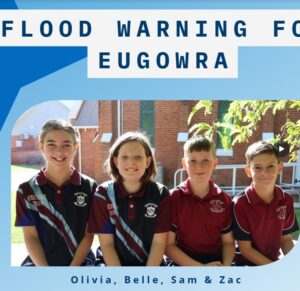
Young St Joseph’s PS students from Eugowra NSW have developed an early flood warning system for Eugowra after unprecedented floods devastated their town in 2022. They presented their project to expert adults from around the country at the Floodplain Management Australia national conference in Melbourne in May 2025. Their inspiring video is such as great example of student-led inquiry-based practical learning, community collaboration and advocacy, innovation to create an early flood warning system and a powerful way for these students to alleviate some of the trauma they lived through.
|
Murray Darling Basin maps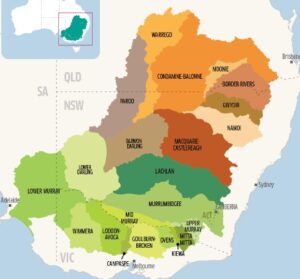
Parts of northern Victoria are part of the Murray Darling Basin, a huge area of eastern Australia that drains water into the Murray and Darling river systems and supports biodiversity, towns and agriculture. For the basin’s boundary click here or to watch a great video on the Murray Darling basin click here.
|
Tullaroop Catchment Project River Health Snapshot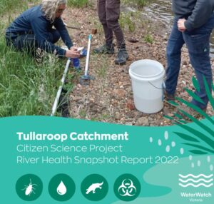
Gauge the health of waterways in the Tullaroop Catchment project area using this compilation of water quality and water bug data collected by citizen-scientists.
|
Kayaking the sickest urban river in Australia video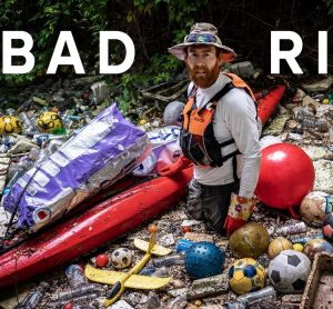
Join Beau Miles as he kayaks 23kms along Cooks River in Sydney over 4 days reflecting on it’s interesting past, it’s disturbing present and it’s hopeful future. An eye-opening journey about the plight of our littered urban waterways in modern society. ** Language warning ** Be aware some language will not be appropriate for younger viewers.
|
Trentham Golf Course benefits from A Healthy Coliban Catchment video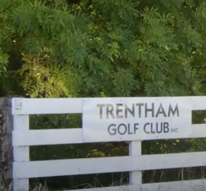
The Trentham Golf Club is keen to make a difference to their local environment, and the Healthy Coliban Catchment project is helping them achieve it. A great example of how waterways are integral to community life and we are all responsible for their health.
|
A Healthy Coliban Catchment project partnerships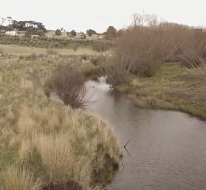
Hear about the collaboration between stakeholders to ensure A Healthy Coliban Catchment; landholders, landcare groups, traditional owners and organisations.
|
Landholders banding together for a healthier Coliban Catchment
A group of Drummond landholders are working together to help improve Kangaroo Creek, as part of the North Central CMA’s ‘A Healthy Coliban Catchment’ project. The project is working with locals to improve water quality and biodiversity of a catchment that provides drinking water for 130,000 people.
|
Healthy Coliban Catchment Project River Health Snapshots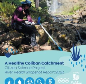
Gauge the health of waterways in the Healthy Coliban Catchment project area using this compilation of water quality and water bug data collected by citizen-scientists. You can also view and compare the 2022 or 2021 reports.
|
Caring for the Campaspe achievements brochure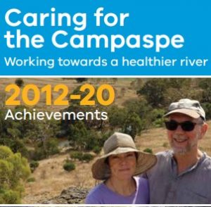
Read about the amazing achievements of this North Central CMA project from 2012-2020.
|
River Moorabool movie
the River Moorabool was made by People for A Living Moorabool (PALM) and Sheoaks Films. It features local landowners, scientists, and healthy river advocates and explores the consequences of water demands on the Moorabool River, particularly in the face of climate change. At 48mins in length it is a compelling watch for senior students to promote deep discussions about water management issues.
|
Desert Lake – The Story of Kati Thanda – Lake Eyre picture book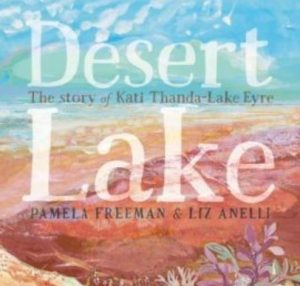
It’s raining up north and soon everything will change for the desert lake. The dry salt bed of Kati Thanda-Lake Eyre shimmers in the desert heat. But far up north, the rains have come. Water is flooding into empty riverbeds and swirling down towards the lake. Soon everything will change. Although Lake Eyre is far from Victoria, this is a beautifully written narrative that explores the unique story of one of Australia’s most amazing phenomenon. It builds an appreciation of the wonder and resilience of nature along with the function of a catchment. There are no online versions of this book but a hard copy or big book version can be ordered at your favourite book store. Alternative teacher notes can be found here.
|
Why do mass fish deaths occur ? videos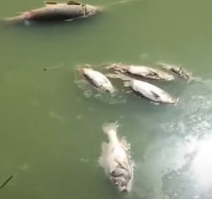
Between December 2018 and January 2019, three mass fish death events happened along a 40km stretch of the Lower Darling River, downstream of Menindee Lakes. Although this event occurred far from us in Victoria it was a highly public and very distressing event for everyone, seeing up to a million fish including 100-year-old Murray cod die in one of the biggest environmental catastrophes to hit the river. The video linked to the title above and this one here help students understand the issues around what happened. Note: views expressed are the opinion of the video producers not River Detectives or any participating CMA. And a warning that some scenes could be distressing for students.
|
Linking the Landscape – The Cobaw Biolink video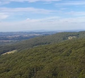
This video by Newham Landcare promotes the important role of the Cobaw Biolink in enhancing the connections between Mount Macedon and the Cobaw Range on both private and public land. Protecting existing high quality vegetation and creating connectivity in the biolink will help native plants and animals adapt to climate change. The video aims to engage the community and make them aware that their contribution, no matter how big or small, can have a positive impact on the environment on a landscape scale, making catchments and waterways healthier and everything that relies on them.
|
Campaspe River resource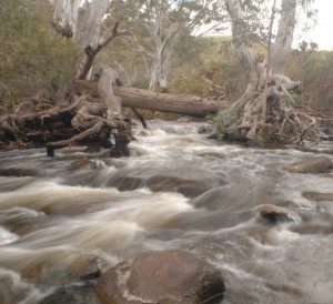
This guide is a great resource for teachers and older students to understand the Campaspe River; catchment, Aboriginal and European history, flows, health and management. Produced as part of the Caring For The Campaspe project, this guide will be a useful resource for the many schools now engaged with the project through the River Detectives program along the Campapse River.
|
What Is A Catchment ? video
This very short video is a simple visual introduction to the concept of a catchment, suitable for all but perfect for younger students.
|
Your hand as a catchment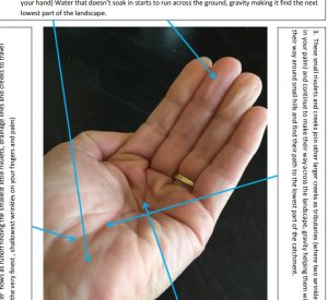
Use this activity sheet to model a catchment with your hand; high points representing hills and wrinkles in your palm representing waterways.
|
River Rehab: Protecting Waterways From Livestock video
Watch this video to see how Tasmania’s farmers are taking measures to reduce degradation of the state’s waterways from livestock. This video introduces students to sustainable farming practices that protect waterways and increase farm productivity simultaneously. Draw your own farm plan and illustrate how it can be managed sustainably.
|
Where Does Water Go After It Rains ? video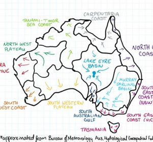
What happens to rainfall in Australia? Water usually flows downhill, and because we know where the hills are, scientists have been able to divide the country into drainage divisions, or catchments. Watch this video to find out which drainage division you’re in, and learn what happens to rainwater that doesn’t make it to the sea.
|
Catchment Mind Map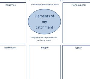
Use this template or use your own method to brainstorm all of the elements that exist within your catchment from natural features such as ranges, waterways, plants and animals to human features such as roads, towns, industry and agriculture and to the ways we enjoy and use the catchment; camping, bike riding, kayaking, sport, etc. This exercise is a good introductory activity (after you’ve established what catchment you are a part of) to highlight all of the elements that need to be functioning well to maintain catchment health and how they are inextricably linked. To extend this activity add arrows/captions to show cause and effect between elements; to demonstrate an unhealthy catchment with negative actions causing negative knock on effects; then compare to a healthy catchment where positive actions cause positive knock on effects.
|
Seasonal Calendars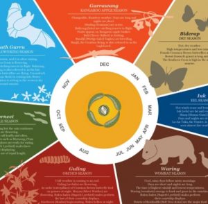
Aboriginal people traditionally lived by seasonal calendars not dictated by the conventions of summer, autumn, winter and spring but by the changes they observed in nature throughout a year. This is one example of a Kulin Nation seasonal calendar. You might be able to source one that is more specific to the traditional owners of your area ? Click here for an outline of the Wotjobaluk seasonal calendar for the Wimmera-Mallee area or view another version at the Visit Grampians website. Click here to watch a video about Dja Dja Wurrung seasons. Keep observations of your waterway and local catchment throughout a year with your students and make your own text or pictorial calendar inspired by a traditional seasonal version or this riparian/agricultural example from the North Central CMA. . . . .or combine the two !
|
Geographic Concepts for a Floodplain and Catchment powerpoint slides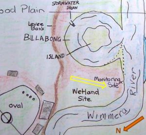
Want to know what some basic floodplain Geographic terms and concepts mean? Jeanie Clark from the Wimmera CMA put together the following three presentations to introduce the basic Geographic terms in a riverine landscape to teachers with little geographic training. Click on the links below to access each one. The slides could also be used with upper primary/secondary students. The Jeparit Showgrounds, Jeparit Primary School’s Waterwatch/ River Detectives site, was used as a local example to describe:
Jeanie is an ex-VCE Geography teacher and can be contacted through the Wimmera CMA for advice/support (time permitting).
|
Catchment to tap video
This video has been produced by Central Highlands Water but the majority of content is relevant to all areas of the state. It features simple explanations of a catchment, the water cycle, how water is shared between users and how water is treated to make it safe in our urban water system.
|
Sharing culture across Wadawurrung country video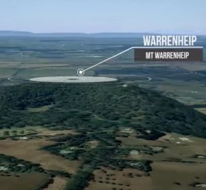
ABC’s ‘This Place’ project invites Aboriginal and Torres Strait Islander people to create a short video about a place name, and the story behind it. Bryon Powell takes us on a journey across Wadawurrung country, sharing some of the stories behind its place names. His country stretches from the mountains to the sea. It includes hills, rivers and grassy plains, creeks and coasts and includes modern towns such as Werribee, Geelong and Ballarat in Victoria. Search for other videos of cultural stories about waterways across regional Australia at the ABC TV Education website, on ABC iview or at the ABC Indigenous youtube channel.
|
On The River picture story book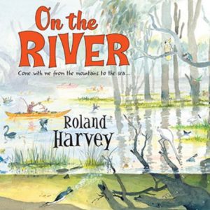
This book is a delight for all ages from the creator of the bestselling At the Beach series. Follow the mighty Murray River from its smallest beginnings in the mountains to where it meets the sea on an epic journey with Roland Harvey and his pelican friend, in this glorious picture book full of humorous, intricate illustrations and fascinating information. Together they discover the story of the river: its secrets, history, ecology, people and animals. And you’re invited, too! There are no online versions of this book but a hard copy can be ordered at your favourite book store. Teacher’s notes are available along with a worksheet for younger readers.
|
Catchment/Waterway photos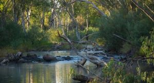
These photos of catchments, healthy and threatened waterways, wetlands and rehabilitation strategies can be used as a springboard for discussion, in conjunction with lessons in the Waterways Environmental Education Resource (see Topics-Waterways) or with some of the activities on the Waterways activity matrix found under the Dive Deeper tab.
|
“The Rhythm of the Rain” picture story book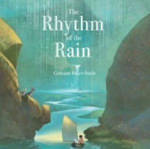
The Rhythm of the Rain by Graham Baker-Smith is a magical book for any educator to launch a lesson or a unit on the water cycle, on the geography of our planet, on the diversity on our planet…there are so many themes hidden within. This story will stretch students’ imaginations, their curiosity, their appreciation of the amazing natural world that surrounds us and nourishes us. Thanks to Alice from Coliban Water in the north central region you can watch a reading of the book as a springboard to other discussions and activities around the water cycle, catchments and the responsibility we all share around the world to conserve water for everyone. Use the links above and below this post to access your local water authority and get involved in their education resources and incursions.
|
North East CMA region map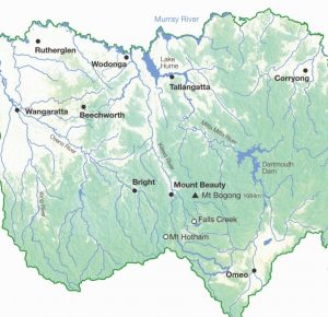
The North East CMA region is one of ten CMA regions of Victoria. This map shows the myriad of waterways that exist from the mountains to the Murray, the major towns and the dams that support them.
|
“Where’s Our Water” digital picture story book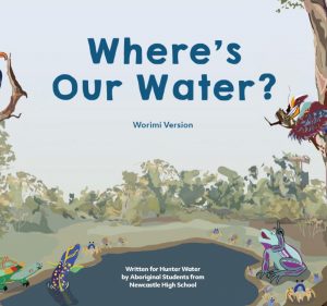
This book came out of a project co-ordinated by Hunter Water in NSW. Although it is not local, the story has valuable messages that apply to any catchment and the project is an inspiring example of what can be achieved when students work closely with traditional owners. Where’s Our Water? has been written for primary school students in the Lower Hunter region to teach them about the value of water as a precious resource and that it is everyone’s responsibility to care for it to ensure we have enough now and into the future. Hunter Water has collaborated with both the Awabakal and Worimi communities to create this new story that draws on their traditional wisdom and practices of caring for our land and waterways. You can also watch a video about the project.
|
NCCMA region Traditional Owner map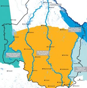
This map (current July 2020) shows the Traditional Owners within the North Central CMA region and it’s catchments.
|
Richardson River’s Journey posters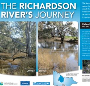
These two posters are an excellent resource for staff and students to familiarise themselves with the Richardson River – it’s; source, path, reaches, catchment, major towns, history, most notable features, flora, fauna and users. The engaging format, stunning photos and user-friendly text makes it the perfect tool for teacher background, student-lead research and learning about an important waterway in the north central region.
|
Coliban River’s Journey poster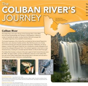
This poster is an excellent resource for staff and students to familiarise themselves with the Coliban River – it’s; source, path, catchment, major towns, history, most notable features, flora, fauna and users. The engaging format, stunning photos and user-friendly text makes it the perfect tool for teacher background, student-lead research and learning about an important waterway in the north central region.
|
Avoca River’s Journey posters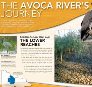
These three posters are an excellent resource for staff and students to familiarise themselves with the Avoca River – it’s; source, path, reaches, catchment, major towns, history, most notable features, flora, fauna and users. The engaging format, stunning photos and user-friendly text makes it the perfect tool for teacher background, student-lead research and learning about an important waterway in the north central region.
|
Loddon River’s Journey posters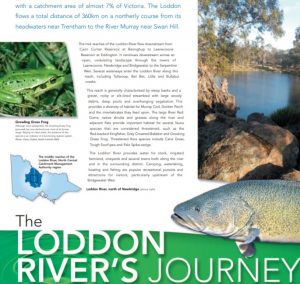
These three posters are an excellent resource for staff and students to familiarise themselves with the Loddon River – it’s; source, path, reaches, catchment, major towns, history, most notable features, flora, fauna and users. The engaging format, stunning photos and user-friendly text makes it the perfect tool for teacher background, student-lead research and learning about an important waterway in the north central region.
|
Campaspe River’s Journey posters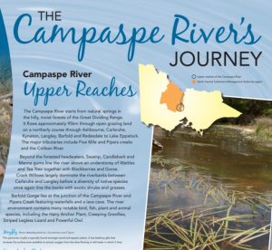
These two posters are an excellent resource for staff and students to familiarise themselves with the Campaspe River – it’s; source, path, reaches, catchment, major towns, most notable features, flora, fauna and users. The engaging format, stunning photos and user-friendly text makes it the perfect tool for teacher background, student-lead research and learning about an important waterway in the north central region.
|
The Wimmera’s Flowing Tale video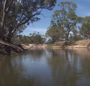
Take a journey along the depth and breadth of the Wimmera River catchment. Produced in 2006, this short film is a fantastic look back at our river system. It focusses on how Wimmera CMA looks after the catchment and how they manage environmental water releases. Although many things have changed since this film was made, such as completion of the Wimmera Mallee Pipeline and more security for environmental water releases, the themes in this flowing tale have stayed the same.
|
North East CMAFind out what the North East CMA does and how they care for catchments in the region. Includes descriptions of the region and projects the CMA is undertaking to protect and enhance environmental values within the region. If you are in the North East CMA region you may also like to access educational support (urban water, water cycles, water conservation) from the water corporation in your specific location using this map. It will most likely be North East Water.
|
Melbourne Water education programFind out what Melbourne Water does and how they care for catchments in the region. Includes a myriad of education resources covering frogs, litter, stormwater, catchments, waterways and more. Some are specific to the Melbourne area but many are relevant to all regions. If you are in the Melbourne Water area you may also like to access support from the water corporation in your specific location using this map. It will either be Yarra Valley Water, South East Water, City West Water or Westernport Water.
|
Corangamite CMAFind out what the Corangamite CMA does and how they care for catchments in the region. Includes descriptions of the region’s catchments and projects the CMA is undertaking to protect and enhance them. If you are in the Corangamite CMA region you may also like to access educational support (urban water, water cycles, water conservation) from the water corporation in your specific location using this map; Depending on your location it may either be Central Highlands Water or Barwon Water,
|
North Central CMAFind out what the North Central CMA does and how they care for catchments in the region. Includes great descriptions of rivers and wetlands in the region and projects the CMA is undertaking to protect and enhance them. If you are in the North Central CMA region you may also like to access educational support (urban water, water cycles, water conservation) from the water corporation in your specific location using this map; Depending on your location it may either be Coliban Water, Central Highlands Water, GWM Water or Lower Murray Water.
|
Wimmera CMA
Find out what the Wimmera CMA does and how they care for catchments in the region. Includes great descriptions of rivers/streams and wetlands in the Wimmera CMA region. If you are in the Wimmera CMA region you may also like to access educational support (urban water, water cycles, water conservation) from the water corporation in your specific location using this map. It will most likely be GWM Water.
|
Wimmera River at Jeparit flows into Lake Hindmarsh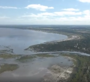
In September 2016 the Wimmera region enjoyed seeing many of their waterways flowing and lakes filling! The CMA filmed the breathtaking sight of Lake Hindmarsh from the air with the majority of the lake’s 139 square km surface area covered by water. Lake Hindmarsh is Victoria’s largest freshwater lake. Previously it filled after the 2011 floods but since then had been dry. It is a popular spot for camping, birdwatching, sailing and brings visitors from around the world. The lake also supports a diverse array of plants and animals including birds, frogs, fish and river redgums.
|
Making Every Drop Count video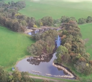
When Ian Campbell and Dr Sue Swaney bought their Deans Marsh farm in 1988, the landscape had only seven trees and a large erosion gully that nearly split the property in half. The transformation they’ve achieved in just three decades is astounding. In recent years the Corangamite CMA’s On-Farm Water Efficiency Project has supported Ian and Sue to design and manage a state-of-the-art farm water supply system to improve outcomes for animal health, catchment health and biodiversity. This is a great example for any region of the responsibility that all landowners in a catchment have toward waterway health.
|
Victorian CMA regions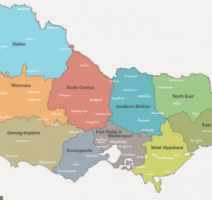
This map shows the Catchment Management Authority regions across Victoria. In each region, CMA’s are responsible for the management of waterways. Maybe you could research what the major waterways are in each region ?
|
Catchments – the sponge effect video
Only around 30% to 50% of the rain that falls on our catchments each year ends up in waterways. For example, only about 10% of rainfall during summer turns into runoff because the dry soil acts like a sponge, soaking up the rain before it can flow into streams. Watch this video to see how this changes from season to season depending on how wet the soil in the catchment is.
|
Urban Water Cycle animations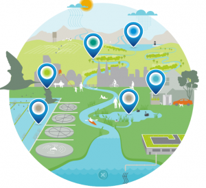
People have changed the natural water cycle; buildings and pipes take water for drinking and remove sewage and stormwater. This is the urban water cycle. In Melbourne the urban water cycle is managed by Melbourne Water. Use this interactive map to learn more or this link to explore other aspects. In north central Victoria Coliban Water manages urban water. Check out their animation with links to videos to explore topics further.
|
Drip Trip game
Join Drippy the raindrop on a journey across the urban water cycle, through your neighbourhood’s water pipes, sewers, drains and waterways as you head towards the bay. This Melbourne Water resource does focus on Melbourne’s urban area but will have some relevance to urban areas in any region. Suitable for ages 12 and above. Drip Trip can be played on smartphones, tablets and computers.
|
Lower Campaspe Flyover video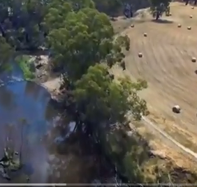
This 9 minute video shows edited footage of a drone journey along the Campaspe River from Axedale (just downstream of Lake Eppalock) to Echuca. Set to peaceful music it is a relaxing way to soar like an eagle over the waterway and start conversations about land practices along the way and strategies to balance river health with productive community life and agriculture.
|
ABC Catchment Detox online game
This is an online game where the player manages a virtual river catchment. The aim is to create an environmentally happy catchment with a sustainable and thriving economy.
|
Murray Darling Basin video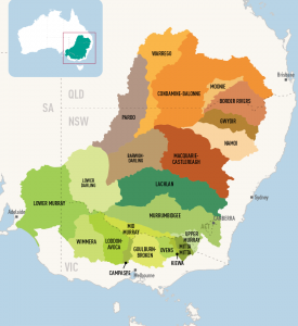
This quirky 12 minute video provides an excellent explanation of how catchments work and the animals, plants, communities and livelihoods that depend on them being well managed. It highlights the importance of balancing the needs of the environment and humans. All waterways North Central, Wimmera and North East CMA regions are part of the southern most section of the Murray Darling Basin.
|
Riparian Zone Poster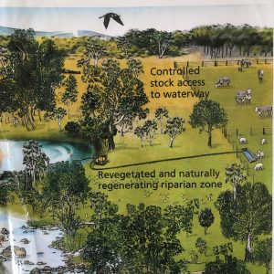
An excellent graphic to highlight the key features of a healthy riparian zone compared to a degraded riparian zone. Great for conversations about water quality, habitat health, land practices and shared community responsibility for the health of our waterways.
|
Wimmera River Catchment map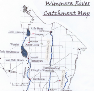
This is a map depicting the catchment area of the Wimmera River. Part of the Wimmera Catchment Management Authority region, the area to the west of the Wimmera River, doesn’t actually flow into the Wimmera River. The West Wimmera area is instead a series of wetland chains.
|
Map your River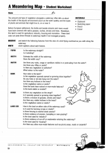
Follow the Teachers Guide to support students to draw a birds eye view of their water testing site with captions to highlight various features. The Riparian Zone Poster could be used as an example.
|
Run of the river board game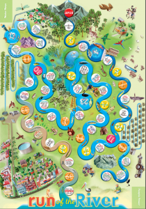
The famous Waterwatch game Run of the River can be taken into the classroom very easily: Download the Board Read the Teacher Instructions And find out How to play
|
What is a catchment?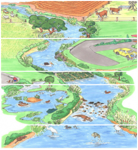
This is useful fact sheet to define and explain catchments. For more detail about how catchments and waterways are interrelated and how they can be protected see this fact sheet for older students.
|
Stormwater fact sheet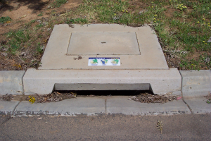
What is stormwater? Where does it come from, where does it go and what can we do to help protect our waterways?
|
Habitats near a waterway – fact sheet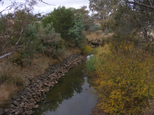
Find out about the different habitats near and in a waterway and why they are important.
|
What is the riparian zone? – fact sheet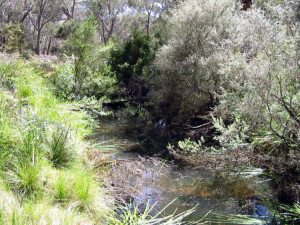
The riparian zone is any land that adjoins, directly influences, or is influenced by a body of water. Find out what the values, threats and management concerns are.
|
Melbourne Water Catchments map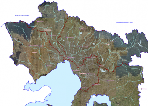
Explore the catchments of Melbourne!
|
North Central CMA Catchment maps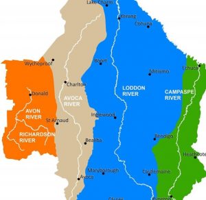
The North Central CMA region is one of ten CMA regions of Victoria. This region has four catchments; Campaspe, Loddon, Avoca and Avon Richardson. These can be broken down further into eleven sub-catchments. Click the links below to find out which catchment/sub-catchment your town/waterway is in. See it from above and understand the way water flows in your area. Upper Loddon Map; Upper Campaspe Map; Upper Avoca River Map; Lower Loddon River Map; Lower Campaspe Map; Lower Avoca Map; Loddon West Map; Loddon East Map; Gunbower Map; Coliban Map; Avon Richardson Map
|
Run of the River Game
This free App by the Murray Darling Basin Authority is educational and fun! You have the following challenge: Water is scarce and needs to be shared around. You must deliver the bubbles of water from the river to the wetlands, farms and communities, whilst keeping the river mouth connected to the ocean. Control dam releases to quench the thirst of all your water consumers through the challenges of flood, drought, evaporation, seasonal changes….
|
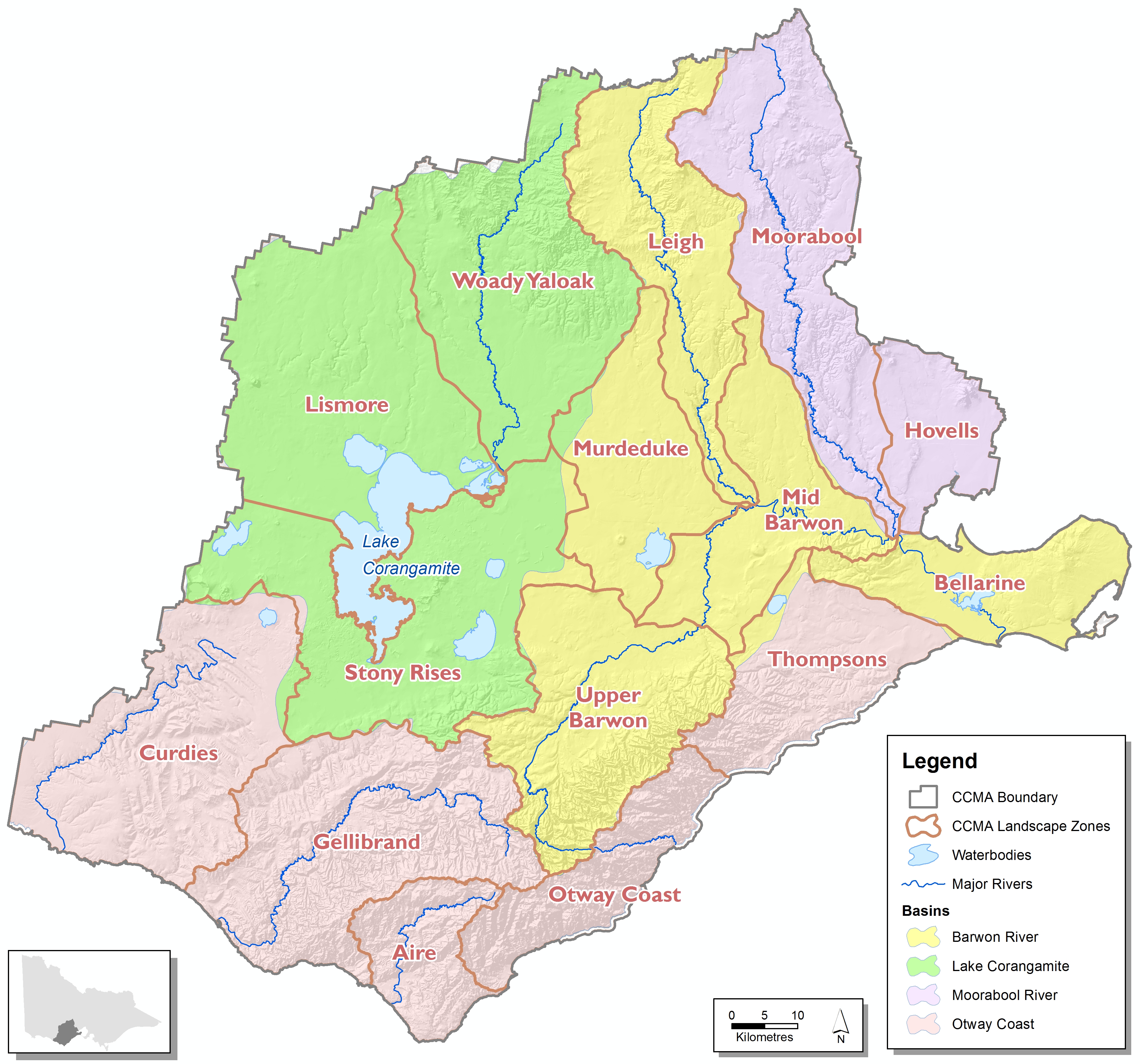
Corangamite CMA Catchment maps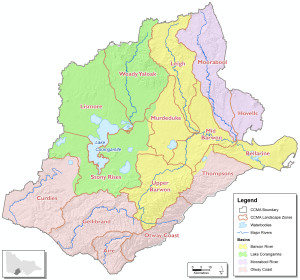
The Corangamite CMA region is one of ten CMA regions of Victoria. This region has four catchments; Barwon River, Lake Corangamite, Moorabool River and Otway Coast. These can be broken down further into fifteen sub-catchments. Click the links below to find out which catchment/sub-catchment your town/waterway is in. See it from above and understand the way water flows in your area. Moorabool, Hovells, Leigh, Murdeduke, Mid Barwon, Upper Barwon, Bellarine, Woady Yaloak, Lismore, Stony Rises, Curdies, Gellibrand, Aire, Otway Coast, Thompsons.
|
Fresh and Salty Booklet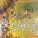
This booklet complements the Fresh and Salty video with teacher notes and lesson plans
|
North Central CMA Region 3D map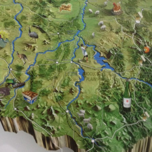
Enjoy a birds-eye view of the North Central region to understand our topography, catchments and land uses.
|
Fresh and Salty video
Fresh and Salty is a highly engaging short animated film produced by the Wimmera CMA. It is the perfect way to introduce the topic of salinity to your students
|