Map
Murray Darling Basin maps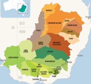
Parts of northern Victoria are part of the Murray Darling Basin, a huge area of eastern Australia that drains water into the Murray and Darling river systems and supports biodiversity, towns and agriculture. For the basin’s boundary click here or to watch a great video on the Murray Darling basin click here.
|
The Bendigo Creek Story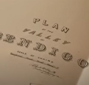
This film traces the history of the Bendigo creek to explore the savage environmental impact of mining on the local environment of the Bendigo goldfields. Features fascinating images of an 1852 unique hand-written and hand-painted map of central Victoria.
|
Plan of the valley of Bendigo 1858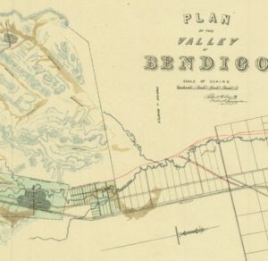
This map drawn by the District Surveyor, Richard Larritt in 1858 shows the alignment of the Bendigo Creek at the time between Kangaroo Flat and Huntly. Goldmining had already taken a significant toll on the landscape by 1858 but this map from the State Library is possibly the best evidence (besides doing archaeological digs) of the original form of Bendigo Creek. As time went on, the Creek was drastically modified to be what we see today. This is a fascinating insight for students in the Bendigo area.
|
Victorian Water Corporations map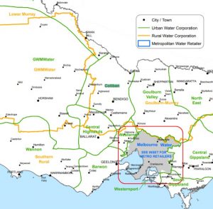
Although the role of water corporations is different to CMA’s (who manage urban water), there is a shared interest in water health/management and the two sectors collaborate regularly. Of great interest to the River Detectives program is the wonderful education services that these water corporations often offer with incursions, excursions, teaching resources and activity sheets for students of all ages looking at urban water, the water cycle and water conservation. Use this map to see which urban water corporation zone your town/school falls in. Head to the group/organisation section of Resource Riverbank for a link to the education tab of each corporation’s website. Consider getting in touch to access their programs, broaden your studies of water and value add to the River Detectives program.
|
North East CMA region map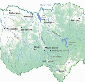
The North East CMA region is one of ten CMA regions of Victoria. This map shows the myriad of waterways that exist from the mountains to the Murray, the major towns and the dams that support them.
|
Environmental Water in Northern Victoria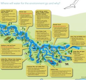
Many of Victoria’s rivers and wetlands have been modified to provide water vital for farms, homes and industry. Water for the environment also benefits communities by improving conditions for fishing, camping and canoeing. Improved water quality can have economic benefits for irrigation and urban water supply. This map shows how water for the environment will help improve and protect plants and animals in northern Victoria in 2020-21.
|
Traditional Owners of Australia – text version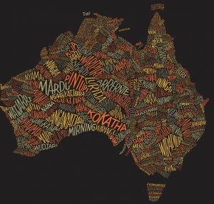
This is a different take on standard maps showing the traditional owner areas across Australia with groups displayed as text rather than shaded colours. It’s an extremely effective way of showing the diversity of Aboriginal cultures.
|
NCCMA region Traditional Owner map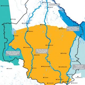
This map (current July 2020) shows the Traditional Owners within the North Central CMA region and it’s catchments.
|
Victorian CMA regions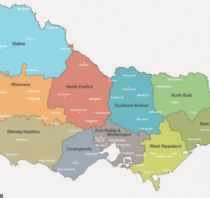
This map shows the Catchment Management Authority regions across Victoria. In each region, CMA’s are responsible for the management of waterways. Maybe you could research what the major waterways are in each region ?
|
Traditional Owners Map
Victoria has a strong and proud Aboriginal history, and complex ownership and land stewardship systems stretching back many thousands of years. This map allows you to find out who the formally recognised Traditional Owners are for an area.
|
Wimmera River Catchment map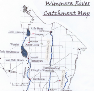
This is a map depicting the catchment area of the Wimmera River. Part of the Wimmera Catchment Management Authority region, the area to the west of the Wimmera River, doesn’t actually flow into the Wimmera River. The West Wimmera area is instead a series of wetland chains.
|
Melbourne Water Catchments map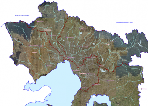
Explore the catchments of Melbourne!
|
North Central CMA Catchment maps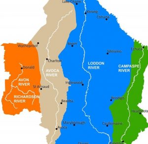
The North Central CMA region is one of ten CMA regions of Victoria. This region has four catchments; Campaspe, Loddon, Avoca and Avon Richardson. These can be broken down further into eleven sub-catchments. Click the links below to find out which catchment/sub-catchment your town/waterway is in. See it from above and understand the way water flows in your area. Upper Loddon Map; Upper Campaspe Map; Upper Avoca River Map; Lower Loddon River Map; Lower Campaspe Map; Lower Avoca Map; Loddon West Map; Loddon East Map; Gunbower Map; Coliban Map; Avon Richardson Map
|
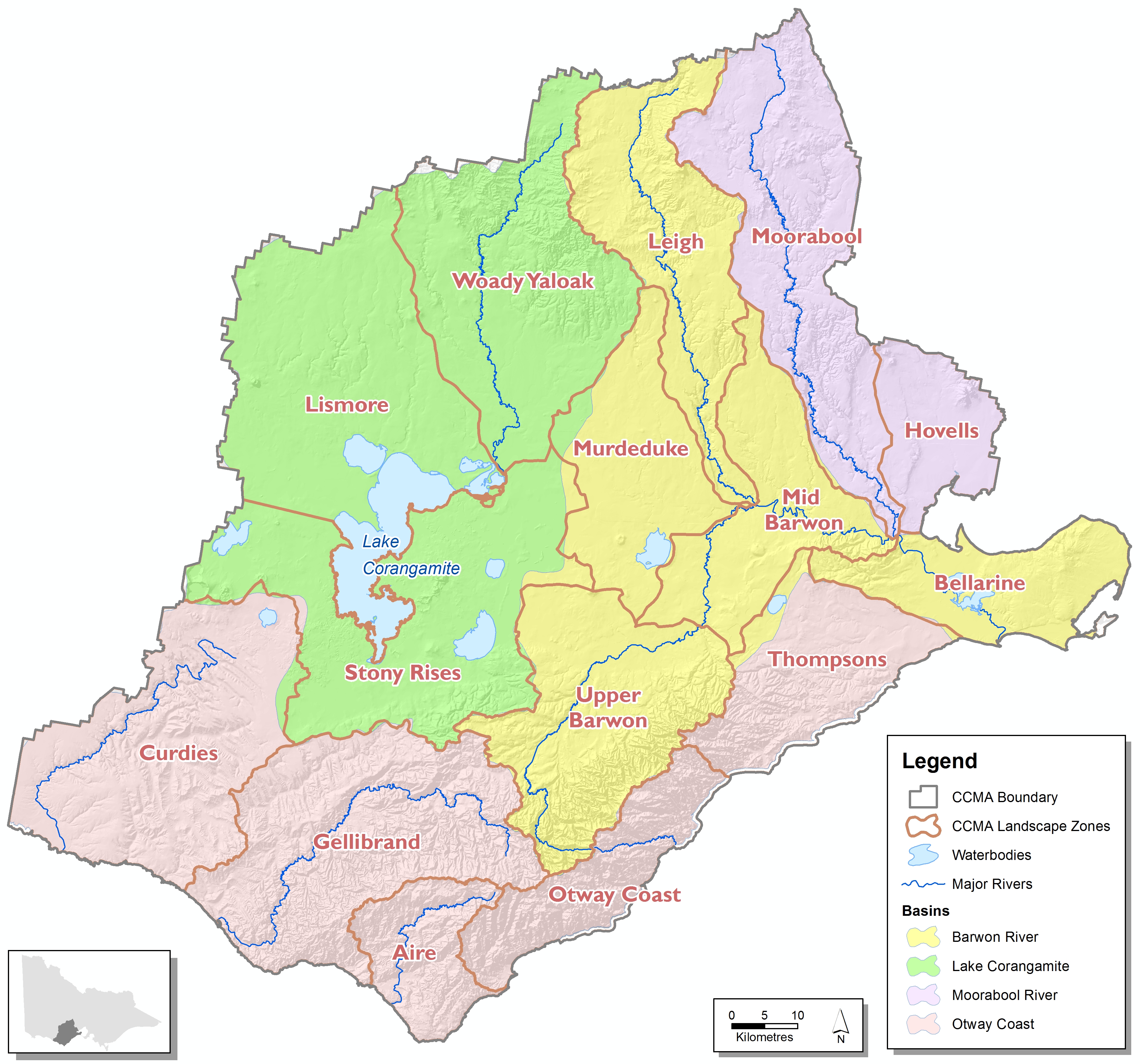
Corangamite CMA Catchment maps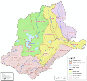
The Corangamite CMA region is one of ten CMA regions of Victoria. This region has four catchments; Barwon River, Lake Corangamite, Moorabool River and Otway Coast. These can be broken down further into fifteen sub-catchments. Click the links below to find out which catchment/sub-catchment your town/waterway is in. See it from above and understand the way water flows in your area. Moorabool, Hovells, Leigh, Murdeduke, Mid Barwon, Upper Barwon, Bellarine, Woady Yaloak, Lismore, Stony Rises, Curdies, Gellibrand, Aire, Otway Coast, Thompsons.
|
North Central CMA Region 3D map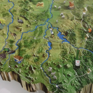
Enjoy a birds-eye view of the North Central region to understand our topography, catchments and land uses.
|